The Parish of Henlow in General
Landscape
According to the Victoria County History (VCH) originally published in 1908 the parish of Henlow was generally flat with a slight slope from south to north. It rises from 107 feet at its lowest point to 169 feet at its highest. The rivers Hiz and Ivel run along the eastern boundary and a small tributary of the Ivel runs rises near Henlow End and runs north. The parish covered 2,377½ acres. Of this 1,700¼ acres comprise arable land and 319¼ permanent grass. The soil is clay and gravel and the subsoil comprises gault, a thick heavy clay. Wheat, barley, oats, beans and peas are the main crops.
Kelly’s 1924 directory places Henlow 36 miles from London, 11 miles south east of Bedford and 2½ from Shefford and 4½ miles south west of Biggleswade.
Two miles to the south of the village is Henlow station on the Bedford and Hitchin branch of the Midland Railway.
The church is at the north end set back from the road and close to the park’s main entrance.
The parish was inclosed in 1795 by Act of Parliament.
Administrative History
Henlow is an ancient ecclesiastical parish in the Hundred of Clifton and includes New Town. The parish was originally in the Diocese of Lincoln, but in 1838 it was moved to the Ely Diocese and in 1914 it was transferred to the new Diocese of St. Albans. A Pastoral Order altered the parish boundaries of the parishes of Biggleswade, Henlow and Langford on 26 August 1987 (P99/2/1/30). In 1997 the parishes of Henlow and Langford were brought together as a united benefice, served by one vicar.
Before 1974 Henlow was administered by Biggleswade Rural District Council and following the local government reorganisation in 1974 it was included in the Mid Bedfordshire Council area. Since 2009 it has been part of the Central Bedfordshire unitary authority. It is part of the Biggleswade Civil Registration District and the Probate Court is the Court of the Archdeaconry of Bedford.
For judicial purposes Henlow was included in the Biggleswade Petty Sessional Division when it was created in 1830.
Following the introduction of the New Poor Law in 1834 it was one of the parishes which made up the Biggleswade Poor Law Union. Information about the records that we hold for this Union can be found here https://bedsarchives.bedford.gov.uk/Using_Our_Collections/Collection-Guides/Health-and-Welfare-Records/Poor-Law-Records/Biggleswade-Poor-Law-Union.aspx
Henlow is currently (2021) part of the North East Bedfordshire parliamentary constituency.
Name
A. Mawer and F. M. Stenton in their 1926 publication The Place-Names of Bedfordshire and Huntingdonshire tell us that the name Henlow is of Old English origin, Hænna-hlāw, meaning fowls’ hill.
Henlow is recorded in the Domesday Book as Haneslauue, Hanslau, Hanslaue and Haneslau. Variations over the following 250 years include:
- Hanlaga: 1202
- Hennelawe: 1207
- Hanlawe: 1220
- Henlawe: 1227 onwards
- Anelawe: 1227
- Hanlowe: 1276
- Hannelowe: 1282
- Henlowe: 1302 onwards
Trade and Business
The National Gazetteer of Great Britain and Ireland published in 1868 states that the manufacture of straw plait took place in the area.
The 1924 Kelly’s Directory shows a variety of businesses in the parish, including a garage, wheelwright, shops, beer retailers and inns and the following farms and market gardeners:
- City Field Farm – Charles William Rawlins (over 150 acres)
- Conway House – Lewis Smith, market gardener
- High Street - Percy Maker, market gardener
- Old Manor Farm – Abel Cooper & Son, market gardeners
- Park Farm – Henry Robert Kefford (over 150 acres)
- Town Farm – George William Mager
- John and Edwin Gravestocks, market gardeners
Population
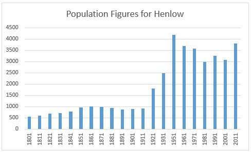
The census returns from 1801 onwards give the following population figures (no census was taken in 1941 due to the Second World War). The steep increase in the population from the 1920s could be explained by the growth of the RAF camp. See RAF Camp timeline for more information.
- 1801: 552
- 1811: 601
- 1821: 688
- 1831: 724
- 1841: 776
- 1851: 970
- 1861: 1011
- 1871: 997
- 1881: 932
- 1891: 879
- 1901: 905
- 1911: 914
- 1921: 1806
- 1931: 2496
- 1951: 4186
- 1961: 3682
- 1971: 3567
- 1981: 2998
- 1991: 3268
- 2001: 3084
- 2011: 3815