The Parish of Harlington in General
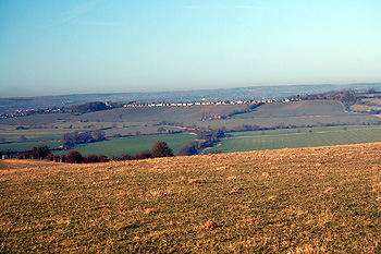
View towards Harlington from Sharpenhoe 1912
Landscape
Harlington is situated on a ridge of boulder clay, sloping down in all directions from the church which stands at 363 feet above sea level. The average height above sea level is 300 feet; Harlington Upper school is 285 feet above sea level and the Station 312 feet; Lovett Green at 235 feet and the garden centre at 222 feet are in the lower part of the parish.
Geologically most of the parish is made up of calcareous gley soils, mainly decalcified boulder clay along the ridge, surrounded by an area of gault clay which changeds by a gradual increase in lime content into a calcareous marl. To the south of the parish there is an area of calcareous gley soil which continues into the parish of Sundon.
When Volume III of the Victoria County History for Bedfordshire was published in 1912 the parish of Harlington contained 1,904 acres, with 784¾ acres of arable land, 1,059¾ acres of permanent grass, and 17½ acres of woods and plantation. The main crops grown in the parish at this time were wheat, barley, beans and green crops.
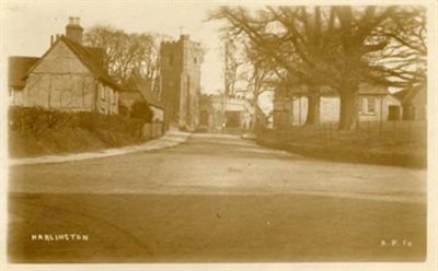
Harlington, looking north up Church Road 1916 [Z1306/53/2]
Administrative History
Harlington is an ancient parish forming part of Manshead Hundred. The parish is surrounded by Westoning to the north, Pulloxhill to the north-east, Streatley to the east, Sundon to the south, and Toddington to the west. Historically the main part of the village was clustered around the crossroads where Station Road, Church Road, Westoning Road and Sundon Road meet, with separate small settlements at Goswell End to the north and Upper and Lower East End to the north-east. The parish also included a detached part at Harlington Woodend, but this is now included in the parish of Westoning. At the time of writing (2020) the village has expanded to the west where the built-up area now extends to the railway line, and to the north and east as far as Goswell End and Upper East End. There has been little development to the south, giving the village an upside-down “L” shape.
From 1891 Harlington was administered by Ampthill Rural District Council; following the reorganisation of local government in 1974 it was included in the Mid Bedfordshire Council area, and since 2009 it has been part of Central Bedfordshire unitary authority. For judicial purposes it was included in the Woburn Petty Sessional Division, between 1875 and the end of the 19th century it was transferred to the Ampthill Division. The parish was moved back to the Woburn Division until it was disbanded in 1953 and Harlington was transferred to the Luton Division. Following the introduction of the New Poor Law in 1834 it was one of the parishes which made up the Woburn Poor Law Union. When this was dissolved in 1899 Harlington was transferred to the Ampthill Union. At the time of writing (2020) it is part of the Mid Bedfordshire parliamentary constituency.
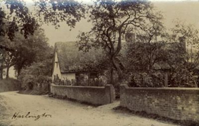
Thatched cottage at Harlington 1905 [Z1306/53/10]
Name
The name Harlington is of Anglo-Saxon origin and means “hill of Herela's people ”. “Harl” is a contraction of an Old English personal name, Herela; “ing” is a contraction of Old English “-ingas”, meaning “the people of …"; and “ton” or “dūn" is Old English for "hill”. In the Domesday Book of 1086 Harlington appears as Herlingdone.
Population
Census returns enable us to chart the changes in the population of Harlington from 1801:
-
1801: 344
-
1811: 352
-
1821: 398
-
1931: 481
-
1841: 521
-
1851: 597
-
1861: 529
-
1871: 546
-
1881: 536
-
1891: 504
-
1901: 530
-
1911: 609
-
1921: 554
-
1931: 607
-
1951: 620
-
1961: 862
-
1971: 2025
-
1981: 2435
-
1991: 2278
-
2001: 2322
-
2011: 2297
The slight decline in population after 1871 is accounted for by the great agricultural depression from about 1873 to about 1896 when people were forced off the land and into nearby towns in order to find work. There was a large jump in population between 1961 and 1971 as the convenience of the mainline station in the village attracted commuters.
Further Information
PL/AC2/62: Harlington, A History of the Village (V. de Hoog)