Slip End Maps
To see a larger version of the map please click on the appropriate thumbnail
 1st ed 1880_350x248.jpg)
Ordnance Survey 25 inches to the mile 1st edition map of the northern part of Slip End in 1880
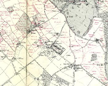
 2nd ed 1901_350x219.jpg)
Ordnance Survey 25 inches to the mile 2nd edition map of the northern part of Slip End in 1901
 3rd ed 1924_350x219.jpg)
Ordnance Survey 25 inches to the mile 3rd edition map of the northern part of Slip End in 1924
 1st ed 1880_350x236.jpg)
Ordnance Survey 25 inches to the mile 1st edition map of the southern part of Slip End in 1880
 2nd ed 1901_350x219.jpg)
Ordnance Survey 25 inches to the mile 2nd edition map of the southern part of Slip End in 1901
 3rd ed 1924_349x226.jpg)
Ordnance Survey 25 inches to the mile 3rd edition map of the southern part of Slip End in 1924
The second edition Ordnance Survey 6 inches to the mile map annotated by the first County Archivist Dr. George Herbert Fowler to show field names in Slip End and Woodside.