1819 Map of Friday Street
Please click on the map above to see a larger image
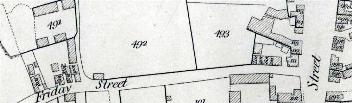
The map above is part of a larger map published in 1819 by Benjamin Bevan junior [X1/34/1]. In 1821 William Rose of Leighton Buzzard published a reference booklet to accompany the map [X1/34/2]. This booklet gave the owner and occupier of the various buildings and pieces of land on Bevan's map. Below is a transcript of the reference book corresponding to this section of the map. Each entry consists of the number, then the name of the owner, then the name of the occupier or occupiers.
Friday Street [later West Street]
East to West
- 110: J.Stevens; R.Hemming;
- 109: J.Stevens; E.Coltman;
- 108: J.Stevens; J.Edmunds;
- 107: J.Stevens; Robert Turnham;
- 493: J.How; J.How;
- 492: W.R.Lawford; W.R.Lawford;
- 491: T.Doggett; T.Doggett;
- 106: S.Reeve; T.Pratt [the lane running along the eastern edge to 491 is Doggett's Path];
- 105: S.Reeve; James Reeve;
- 104: S.Reeve; W.Pearce;
- 103: W.Tring; W.Tring;
- 102: J.Grant; T.Kitley