Holly Tree Farm Heath and Reach
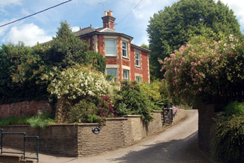
Holly Tree Farm June 2008
When Heath and Reach was inclosed in 1841 John Millard was allotted the lands which would become Holly Tree Farm. The land comprised 74 acres 1 rood 11 poles made up of 28 acres 32 poles in Middle Field and 30 acres 3 roods 30 poles in Middle and South Mead Fields with smaller areas of land, shown on the map below coloured yellow, nearer the farmhouse:
- 83: Cottages and gardens - 27 poles;
- 99: Upper Close - 10 acres 1 rood 34 poles;
- 102: Home Close - 3 acres 27 poles;
- 111: the farmhouse and homestead - 1 acre 29 poles;
- 114: cottage and gardens - 1 rood 12 poles.
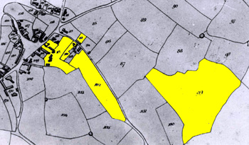
Holly Tree Farm in 1841 - land near the farm
The Rating and Valuation Act 1925 ordered every piece of land and building in the country to be assessed to determine the rates to be paid on them. Heath and Reach was assessed in 1927 and the valuer visiting Holly Tree Farm [DV1/C254/23] noted that the house was owned and occupied by a Mrs.Claridge and that it stood in 1.130 acres. The house was built of brick and slate and was detached. By this time the place was not really a farmhouse, though Mrs.Claridge owned a 12.546 acres field south of Eastern Way just west of the junction with Overend Green Lane and other land along Reach Lane used for sand quarrying as well as 9 Gig Lane.
Accommodation comprised a kitchen, scullery, larder, pantry, W.C., morning room, drawing room, dining room, passage hall and a further W.C. downstairs with a servant's bedroom, bathroom, W.C., landing, dressing room, store room and two bedrooms above. A cellar lay beneath. The valuer made a number of comments as follows: "Portico over front door"; "Not a good enough situation for a house of this type"; "Traffic up the hill"; "Farmhouse type"; "Nice lawns"; "Most of buildings let off"; "Saw Mrs.Claridge 19/8/27. Gas. Water pumped by hand from well. Cesspool drainage. Been here 25 years".
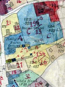
Holly Tree Farm on the 1927 valuation map
The valuer itemised the building outside as follows [coloured blue on the plan]:
- A - lawns and flower beds, tennis court;
- B - tile and thatch summer house;
- C - kitchen garden, wood and brick tool shed;
- D - greenhouse 18 feet by 10 feet heated;
- E - weather boarded and slate part barn;
- F - two weather boarded and tiled loose boxes
- G - weather boarded and tiled harness room
- H - weather boarded and slate trap shed, weather boarded and tiled coal shed "adjoins house"
The adjoining land [C254/26] was occupied Waste Recovery Syndicate Limited at a rent of £30 per annum and the valuer noted: "Not farm. Buildings used as stables for horses in connection with sandpits". He itemised the buildings as follows [coloured yellow on the plan]:
- A - weather boarded and tiled forage store, office, stable with three stalls ("forage store at end"); weather boarded and tiled harness room;
- B - four bay open fronted cart shed; lean-to shed; weather boarded and slate loose box;
- C - two loose boxes; stable for five horses; two stables for two horses; weather boarded and slate part barn;
- D - granary with a loft over; 4 horsepower oil engine with 10 feet of 1½ inch shafting.