Chances Pit Heath and Reach
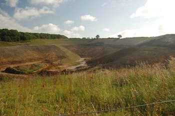
Stone Lane Hill and Chances Pit June 2008
James Timmins Chance and Robert Lucas Chance were admitted as tenants to Calves Close of three acres and Great Pear Pond Close of four acres in 1842 and 1858 respectively. Beneath the land lay a stratum of silver vitreous sand from 28 to 45 feet deep and 20 to 30 feet from the surface. The land was owned by the Manor of Leighton Buzzard alias Grovebury and there was no manorial custom for tenants to dig for minerals. The Chances, however, by 1863 were taking around a hundred tons per week for use in glass manufacture. Colonel Henry Hanmer (tenant of the Manor under the Dean and Canons of Saint George's Chapel, Windsor) decided to see whether the Chances could be fined for their actions, in other words whether he could get any cut of the profits of their activities. The opinion of counsel was that the tenants of the manor could not dig new pits for sand but if it could be proved that the pits were of longstanding (say thirty years) there was effectively no remedy [KK922].
Hanmer went ahead with a Bill of Complaint in Chancery against the Chances in 1863 [KK923] as they had been mining the sand for less than thirty years. A letter from Charles Edward Jones, steward of the manor, quoted in the bill of complaint, gives the other grounds for the action: "Colonel Hanmer has within the last few weeks purchased of the Dean and Canons of Windsor the freehold the manor and has acquired the absolute property in all minerals including of course sand beneath the copyhold lands of the manor". Hanmer wanted the Chances to buy a licence from him to mine. The solicitor for the Chances argued that they had a right to mine the sand without a licence.
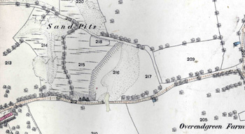
Great Pear Pond and Calves Closes 1882
Frustratingly, the result of the case is not noted in the archive but some of the evidence gives a good idea of the mining operations. John Clutton and George King, surveyors employed by Hanmer noted as follows [KK924]: "that on the 17th day of May last I went over and examined Great Pear Pond Close and Calves Close aforesaid the former appears to have been excavated over its entire surface of 2 acres 3 roods 30 poles with the exception of about 30 poles thereof and its present appearance is that of a large spoil bank with a roadway cut through it part being an open excavation or pitt having an area together with such Roadway of about 20 poles and such Roadway having a depth from the original surface of the Field of as I estimate about 20 feet. In Calves Close aforesaid I found the Defendant s' excavations proceeding and a portion to the extent of ¾ of an acre or thereabouts excavated to a depth of from 70 to 80 feet and sand having been taken therefrom and the overlying soil or the greater portion thereof removed and deposited on what I have before described as the Spoil Bank in Great Pear Pond Close aforesaid. The depth of the vein or layer of sand at the point at which the works are now open is from 30 to 33 feet with an overlying stratum of soil of from 40 to 47 feet".
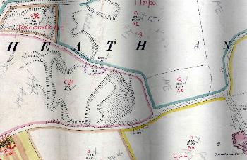
Chances Pit in 1927
Chance's Pit was at some point taken over by J.Arnold & Sons. The Rating and Valuation Act 1925 ordered every piece of land and building in the country to be assessed to determine the rates to be paid upon it. The valuer visiting Chances Pit [DV1/C233/61] merely noted that it was owned by Arnold and comprised 20.590 acres. He made no mention of quarrying taking place.
This is a little strange as in the May 1934 edition of the wonderfully named Cement, Lime & Gravel an article on the firm included the following: "Chance's Quarry, though smaller [than Double Arches] is quite interesting. Fifteen feet of overburden cover a deposit of fine siliceous sand, so dense in formation that the whole face can be worked to a perpendicular wall without fear of premature falls. However, no such risk is taken as it is more convenient to work in benches for selection purposes. The overburden is stripped by a Thew Steam Shovel on caterpillars".
"This fine siliceous sand is the bed underlying all the other quarries in this particular area, but it is not found everywhere in the locality. The whole series comes under the name of the Lower Greensand, which lies uncomfortably on beds of the Jurassic System, as the Wealden beds are absent owing to a northerly overlap of the beds of the Cretaceous System, of which the Lower Greensand forms part. It is perhaps for this reason that this particular deposit of fine siliceous sand disappears to the north of Leighton Buzzard". It may be that the pit had not been worked, for some reason, in 1927 and was reopened before 1934.
In the latter part of the 20th century the pit was joined with the much smaller Stone Lane Hill pit. The path which used to run between them, shown on the map meeting Bryants Row west of Overend Green Road was then obliterated. This new enlarged pit finally closed in the latter half of 2008 and is currently [2009] grassing over with a small lake in the bottom.
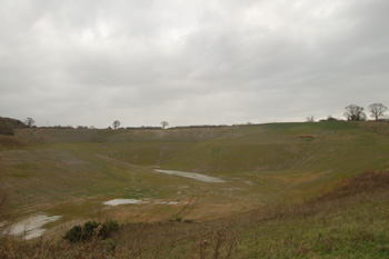 Stone Lane Hill and Chances Pit November 2008