Wilshamstead Before 1086
The Bedfordshire Historic Environment Record [HER] contains information on the county’s historic buildings and landscapes and summaries of each entry can now be found online as part of the Heritage Gateway website. The earliest evidence of human activity in what is now Wilshamstead comes from Saint Macute’s Wood where a flint axe from the Mesolithic Period was found [HER 9851]. It is now in Bedford Museum. A flint axe from the Neolithic Period has also been found in neighbouring Wilstead Wood [HER 14807]. It lay on the left-hand side of the path leading south from Wilshamstead.
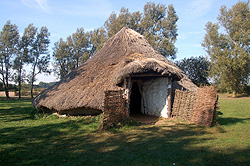
A reconstruction of an Iron Age round house at Flag Fen October 2011
A number of pieces of evidence of Iron Age occupation come from Wilshamstead. Iron Age pottery has been found [HER 1901] and a site has been identified south of Manor Farm [HER 18188]. This has revealed early and middle period evidence including post holes from two round houses, a large enclosing ditch, six linear gullies, perhaps for drainage, and a well. A cremation and an intact burial were also found along with animal bones, a crucible, a quern for grinding corn and pottery. The site also produced flint tools from the late Mesolithic and the early Neolithic periods.
Another site lay around Longmeadow Drive [HER 18220 and 18221] beneath the modern housing development. This was a farmstead that was replaced by a farm in the Romano-British period. The site produced animal bone and pottery as well as evidence of buildings and flint tools from the Early Neolithic through to the late Bronze Age.
Three crop mark sites in the parish may be evidence of prehistoric activity but without archaeological excavation it is impossible to say for certain. Two rectangular enclosures surrounded by ditches lie just east of the A6 about half way between the spots where Bedford Road and Luton Road respectively join the trunk road [HER 7142]. North-east of Duck End lies a confused area in crop marks, some roughly rectangular others just lines, they may represent a trackway with a double ditch either side with enclosures of various sizes around [HER 16302]. Finally a considerable distance north of Cotton End Road and near the parish with Eastcotts is an area of small curved crop marks together with a number of geological features [HER 16658].
There are three features in Wilshamstead which date from the Romano-British period. An agger runs east of New Farm [HER 10477]. An agger is a slightly raised linear feature, sloping down slightly from the mid-line and with remainders of ditches along either side. It represents the remains of a Roman road. Roman kilns have been discovered at New Farm, to the west of the agger [HER 3637]. The kiln itself does not survive but waste products indicate its original presence. Finally, an area of occupation has been discovered north-west of Duck End Farm [HER 18262]. Archaeological excavations ahead of the development of the development of Wixams uncovered pits, ditches and pottery dating from the late Iron Age well into the Romano-British period.