The Parish of Whipsnade in General
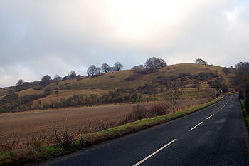
Bison Hill December 2008
Landscape
The village of Whipsnade lies on top of the Dunstable Downs which fall away sharply in the south of the parish. The bulk of the parish’s solid geology is a type of chalk called Lewes Nodular Chalk Formation and Seaford Chalk Formation (Undifferentiated). This was laid down between 84 and 94 million years ago in the warm, shallow seas of the Cretaceous Period. The lower slopes of the downs, including the area of the chalk-cut White Lion figure are a type of chalk called Holywell Nodular Chalk Formation and New Pit Chalk Formation (Undifferentiated). This was also laid down in the Cretaceous Period between 89 and 99 million years ago. Most of the inhabited area of the parish and the zoo has a soil of the clay with flints type, though along watercourses the soil is a mixture of sand, gravel, clay and silt called Head.
Whipsnade church stands at a height of 695 feet above sea-level. The entrance to the zoo is higher at 741 feet with the penguin pool at 729 feet above sea-level. The roundabout on the B4540 stands at 646 feet and the Old Hunters Lodge at 660 feet above sea-level. The White Lion chalk figure lies between 599 and 688 feet above sea-level.
Today the parish of Whipsnade has Studham to the south. The western part of the northern boundary is occupied by Eaton Bray and the east by Kensworth. Immediately west in the Buckinghamshire parish of Edlesborough and immediately east the Hertfordshire parish of Markyate.
![Whipsnade [DV2-E34]](/CommunityHistories/Whipsnade/WhipsnadeImages/Whipsnade [DV2-E34].jpg)
Name
The name Whipsnade is the combination of an Anglo-Saxon personal name with the word “snæd” meaning a piece of woodland – “Wibba’s wood”. The settlement is not mentioned in the Domesday Book of 1086, the earliest reference being in Rolls of Assize for 1202. The name has undergone a large number of variations through history as the following list demonstrates:
- Wilbesnede: 1202;
- Wibsnede: 1202-1287;
- Wybsnede: 1202-1287;
- Wybbesnathe: 1227-1332;
- Winnesnethe: 1227;
- Wyppesnade: 1227-1382;
- Wylnesnethe: 1227;
- Wibbesnade: 1236-1333;
- Wybbesnade: 1236-1333;
- Wybesnade: 1236-1350;
- Wibesnade: 1236-1350;
- Wipesnade: 1247;
- Wylbesnad: 1247;
- Wybesnathe: 1247;
- Wybbesned: 1247-1276;
- Wybbesnet: 1276;
- Websnade: 1299-1374;
- Wypsnade: 1352-1491;
- Wipsnade: 1352-1491;
- Webesnad: 1374;
- Wipsonade: 1421-1441;
- Wyppysnade: 1526
Administrative History
Whipsnade does not appear in Domesday Book and may have been a hamlet with a chapel of ease of a nearby parish, possibly Eaton Bray, thought a coroner's roll for 1274 describes Whipsnade Wood as being in the parish of Houghton Regis. Whipsnade lay partly in the Manshead Hundred of Bedfordshire and partly in the Dacorum Hundred of Hertfordshire. However, it was certainly a separate parish before 1291. In 1897 the Hertfordshire portion of the parish was lost when it was taken to help create the new Hertfordshire civil parish of Markyate.
The South Bedfordshire (Parishes) Order 1985 grew Whipsnade quite dramatically in area. It gained the area of the zoo and the slopes beneath, including the White Lion chalk figure, along with an area west of the road to Dagnall on the upper slopes from Studham along with Heath Wood, Byslip Wood and one other small piece of uninhabited land. A tongue of land heading north from Dukes Avenue was gained from Eaton Bray. It also gained some uninhabited areas to the east from Kensworth whilst giving Shortgrove Manor Farmhouse to Kensworth [MCDP87/5].
![Golden Row Cottages in 1915 [Z214/3]](/CommunityHistories/Whipsnade/WhipsnadeImages/Golden Row Cottages in 1915 [Z214-3].jpg)
Golden Row Cottages in 1915 [Z214/3]
Population
Whipsnade has never been a large place as the population figures taken at census show:
- 1801: 140;
- 1811: 169;
- 1821: 199;
- 1831: 204;
- 1841: 211;
- 1851: 183;
- 1861: 195;
- 1871: 205;
- 1881: 185;
- 1891: 151;
- 1901: 125;
- 1911: 113;
- 1921: 94;
- 1931: 87;
- 1951: 251;
- 1961: 574;
- 1971: 585;
- 1981: 473;
- 1991: 470;
- 2001: 458;
- 2011: 420
The population began to fall significantly with the Long Depression of 1873 to 1896 which forced many people off the land and into nearby towns such as Dunstable. There was a further fall due to part of the parish being taken to create Markyate in 1897.
The population figures for the parish began to rise again after World War Two, significantly between 1951 and 1961 with the building of new homes.