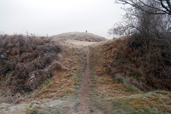
Bank and ditch leading to the inner bailey December 2008
The Castle Hill dominates the village of Totternhoe and the lower land all around it. It is hardly surprising that it was the site of a Norman castle and may have been used for defensive structures in the centuries preceding the Norman Conquest or even in prehistory though, if so, such structures were obliterated by the Norman works and by stone quarrying.
The Bedfordshire Historic Environment Record [HER] has this to say about Totternhoe Castle [HER 533]: "The site comprises a motte and bailey castle occupying the western end of the Totternhoe Ridge (a northern projection from the chalk hills of the Chiltern escarpment), together with a series of medieval quarries cut into slopes to the north and north-west and a flight of cultivation terraces, or lynchets, arranged within a steep-sided coombe to the east".
"The earliest written reference to the castle appears in a grant of land to Dunstable Priory dated between 1170 and 1176, where it was called "castellaria de Eglemont". The builder of the castle is thought to have been one of the Domesday lords [i.e. holding land in Totternhoe as recorded by the Domesday Book], probably Walter de Wahull, who also built castles in the parishes of Odell, Podington and Thurleigh".
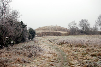
View to the motte from the outer bailey December 2008
"The central defensive position within the castle, the motte, is a conical earthen mound about 5 metres tall, set on the highest point on the spur overlooking the Ouzel valley and crowned by a concrete Ordnance Survey triangulation point (BN S4552). The mound has a diameter of 40 metres at the base and 14 metres at the summit, and is surrounded by a broad ditch of variable width on all but the south-western side where the ground falls away steeply at the edge of the spur. A slight hollow in the top of the motte marks the location of an unrecorded antiquarian investigation, although the raised rim may also conceal the base of a stone tower noted by Lamborn in 1859".
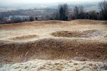
View from the motte to the inner bailey December 2008
"The motte is enclosed between two baileys situated immediately east and west. The smaller western bailey is an oval enclosure measuring approx 63 metres by 80 metres defined by a broad bank, except on the south west side where defence was provided by an artificial scarp accentuating the slope of the spur. The second bailey surrounds the north and east sides of the motte and is separated from the first bailey (and the motte) by an 8 metre wide ditch and a broad counterscarp bank. This bailey is roughly triangular in plan, measuring approx 100 metres north to south by 30 metres east to west, enclosed to the east by a 12 metre wide bank, a broad external ditch and a counterscarp bank. A well shaft, known locally as "the Money Pit", lies toward the western side of the bailey. Dressed building stone was recovered from the shaft when it was excavated to a depth of 34 feet in the early 20th century".
"A third bailey, or outer ward, lies immediately to the east of the motte and inner baileys. This is rectangular in plan, measuring 90 metres in width and extending 150 metres eastwards along the spur. The level interior is contained by a well-defined scarp increasing the severity of the natural slope to the south west. To the south-east the boundary is formed by a substantial ditch 10 metres wide by 3 metres deep and an internal bank 12 metres wide and 2 metres high, providing a formidable rampart broken only by a single gap at the southern end. The ditch and bank remain visible at the eastern corner of the bailey, although the north-eastern arm is now only marked by a slight scarp and traces of the internal bank. Material from the bank may have been used to infill the flanking ditch, now thought to lie buried beneath the adjacent bridleway".
"In the 19th and 20th centuries there was speculation concerning a pre-medieval origin for the castle, but small excavations in the early 20th century found no evidence. The castle does occupy a position similar to that of possible hillfort sites in the Chilterns, and the presence of earlier earthworks within the medieval fortification is not discounted. Geophysical survey within the outer bailey revealed a series of buried ditches forming an irregular grid on markedly different alignment to that of the bailey; these may be the remains of an earlier field system, possibly Iron Age".
The mound, or motte, would have been the site of a timber built tower, perhaps two storeys high, used as a lookout point and, perhaps, an armoury. The lord's hall and private apartments, together with buildings such as the chapel and, perhaps, the lord's stable would have been in one of the inner baileys. The outer bailey or ward and, perhaps, one of the inner bailies would have contained stables, smiths' forges, barrack blocks and places of refreshment for the garrison though a considerable amount of the outer bailey would have been left free for exercising men and horses. The castle would almost have been like a second, self-contained village above the village itself. The walls to the baileys would have been wooden initially though, as the Historic Environment Record makes clear, some stone has been found on the site and may have augmented the wooden defences over time.
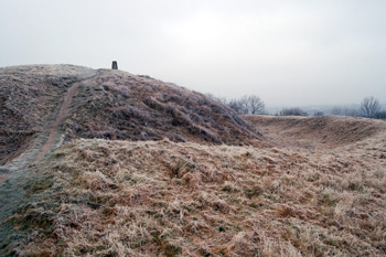
Motte bank and ditch December 2008