Lower Dean Maps
The following maps are only a selection of those held at Bedfordshire and Luton Archives and Records Service.
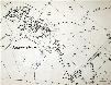
The image below is taken from the inclosure map for Dean of about 1802 [MA21]. To see a larger version, please click on the image.
![Lower Dean about 1802 [MA21]](/CommunityHistories/LowerDean/LowerDeanImages/Lower Dean about 1802 [MA21]_101x67.jpg)
The image below is taken from the 2nd edition Ordnance Survey map for Lower Dean of 1901; again, to see a larger version please click on the image.