The Parish of Hockliffe in General
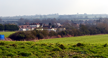
The village seen from Church End February 2013
Landscape
Volume III of The Victoria County History for Bedfordshire was published in 1912. At that date the parish of Hockliffe contained 1,028 acres of which 191 acres were arable and 626 used for grazing animals; just over 2 acres were woodland. Clipstone Brook and its tributaries flow through the parish, with Watling Street crossing Clipstone Brook just to the north of the junctions with Woburn and Leighton Roads.
The church stands at a height of 401 feet above sea level. The junction of Woburn Road and Watling Street is at 329 feet, slightly higher than the lowest point of the parish which is 322 feet. Hockliffe lies at the point where two topographically distinct areas meet and the landscape contains elements of both. The parish is dominated by streams and spur or ridge ends. In the far north of the parish at Fourne Hill the ground rises sharply to over 425 feet at the southern end of a north-south spur lying between two arms of the Winterborne tributary of Clipstone Brook. To the south-east of Fourne Hill the ground again rises to over 425 feet between two branches of the main Clipstone Brook, and in the far south of the parish another less steep sided ridge runs north-east to south-west between two streams and rises to over 406 feet. [Parish Survey Draft Report, PL/AC2/25]
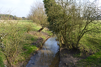
Clipstone Brook at Goose Green February 2013
The solid geology is Gault Formation, a sedimentary rock known as mudstone, formed between 99 and 112 million years ago during the Cretaceous Period when the area was under warn, shallow seas. The superficial geology above this is a mixture of head (a mixture of gravel, sand, silt and clay) in a band across the parish from south-west to north-east and running south-east along Watling Street, and till in the north and north-east of the parish.
Administrative History
Hockliffe is an ancient parish forming part of Manshead Hundred. There are two main areas of settlement, a band of development along both sides of Watling Street, and a small area in the north of the parish around the Church. The parish is surrounded by Battlesden and Chalgrave to the north-east and east, Tilsworth to the south-east, and Eggington and Heath and Reach to the west and north-west. Most of the parish boundaries are man made rather than topographical and it seems likely that Hockliffe was once part of a single large Saxon or earlier estate based on the Leighton Buzzard district and bounded by the River Ouzel and Watling Street [PL/AC2/25].
![Transfer of parts of Chalgrave in 1929 [MCDP34-2]](/CommunityHistories/Hockliffe/HockliffeImages/Transfer of parts of Chalgrave in 1929 [MCDP34-2]_351x263.jpg)
Map showing area transferred from Chalgrave to Hockliffe in 1929 [MCDP34/2] to see a larger version please click on the image
Until the twentieth century the north-eastern side of Watling Street was largely in adjoining parishes, with the area north of Clipstone Brook belonging to Battlesden and the area to the south to Chalgrave. The exception to this was a small section where the historic parish boundary between Hockliffe and Battlesden did not follow Watling Street and for which the boundary was marked by an earthwork [Heritage Environment Record 11682]. It seems likely that this area was taken into Hockliffe from Battlesden in the late medieval or early post-medieval period [PL/AC2/25]. In 1929 an area of 64 acres on the north-east side of Watling Street was transferred from Chalgrave to Hockliffe parish [MCDP34/2]. Under the South Bedfordshire (Parishes) Order 1985 additional land was transferred into Hockliffe from Chalgrave and Tilsworth as shown in the map below; all of this was agricultural land apart from the houses at Nineland [MCDP87/2].
![Transfers to Hockliffe in 1985 [MCDP87-2]](/CommunityHistories/Hockliffe/HockliffeImages/Transfers to Hockliffe in 1985 [MCDP87-2]_219x300.jpg)
Map showing areas transferred to Hockliffe under South Bedfordshire (Parishes) Order [MCDP87/2]
Name
A. Mawer and F. M. Stenton in their 1926 publication The Place-Names of Bedfordshire and Huntingdonshire tell us that Hockliffe means "Hocga's cliff", the "cliff" being the steep spur of land on which the church now stands. The main part of the village is in a depression which led to it earning the popular name of "Hockley-in-the-Hole".
The name has had the following variations over the years:
- Hocganclif: 1015;
- Hocheleia: 1086;
- Hoccliue or Hocclyue: 1185-1388;
- Occliue: 1227-1370
- Houclive: 1247;
- Hoklyue or Hoclyue: 1247-1276;
- Hocclyve or Hoclyve: 1324;
- Oclyve: 1346;
- Hocklyve: 1328;
- Occleue: c.1460;
- Hockley (alias Hockley-in-the-Hole): 1576-1675
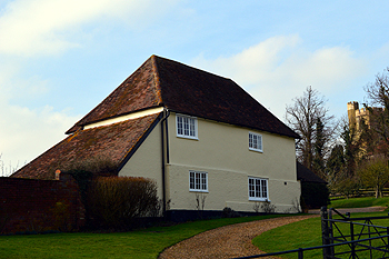
Church Farmhouse February 2013
Population
The Hearth Tax of 1671 (transcribed in Bedfordshire Historical Records Society Volume 16 in 1934) records 32 dwellings in Hockliffe for a total of 83 hearths. It has been estimated that this represented a population of about 136. The largest number of hearths – nine – were in the house of Richard Gilpin at Hockliffe Grange.
The occasional visitation by the Bishop of Lincoln to Bedfordshire in the early 18th century gives important social information. Each vicar or rector had to complete a return about his parish. These are particularly useful for the state of education but give other insights. Former County Archivist Patricia Bell has compiled returns from 1706 to 1720 for the Bedfordshire Historical Records Society (Volume 81, published 2002); the returns for Hockliffe state that in 1709 there were 31 families in the parish and a population of 160; there were 37 families in 1712, 45 in 1717, and 40 in 1720.
Census returns enable us to chart the changes in populations in Hockliffe from 1801:
- 1801: 256
- 1811: 340
- 1821: 393
- 1931: 460
- 1841: 435
- 1851: 439
- 1861: 416
- 1871: 392
- 1881: 326
- 1891: 345
- 1901: 267
- 1911: 255
- 1921: 286
- 1931: 444
- 1951: 477
- 1961: 497
- 1971: 697
- 1981: 679
- 1991: 735
- 2001: 732
- 2011: 823
The decline in population after 1871 is accounted for by the great agricultural depression from about 1873 to about 1896 when people were forced off the land and into nearby towns in order to find work. The large jump in population between 1921 and 1931 is due to the incorporation into Hockliffe of houses on the north-eastern side of Watling Street which had formerly been in the parish of Chalgrave.