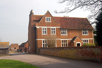
Manor Farmhouse March 2011
Manor Farmhouse was listed by English Heritage in May 1984 as Grade II* of something greater than special interest. It is a late 16th century building of red brick with stone facings and an old clay tiled roof. It was originally built in an H-plan but the south cross-wing was later destroyed. It comprises two storeys and attics. The main room in the main block as an exceptional plaster ceiling (see the photograph below) which may depict the coat of arms of Thomas Colby of London who bought the manor in 1566. The dovecote is listed separately as Grade II. It is 18th century, made of red brick, with a hipped, old clay tile roof with weather-boarding above. It seems reasonable to suppose that this was the manor house of Cotton End Manor.
![The decorated ceiling at Manor Farmhouse [X405/42]](/CommunityHistories/CottonEnd/CottonEndImages/The decorated ceiling at Manor Farmhouse [X405-42].jpg)
The decorated ceiling at Manor Farmhouse [X405/42]
There is a reference to the farm in 1750 but in 1759 a very detailed plan and survey of the farm was drawn up by James Cole [W2/16]. The details reveal that the farm then comprised 130 acres, 1 rood, 26 poles. Another detailed survey which Bedfordshire and Luton Archives and Records Service holds was undertaken in 1822 [BH457].
We are fortunate that three surveys of the parish of Cardington from the late 18th century survive. The first of these was undertaken in 1782 by James Lilburne. He was the parish schoolmaster and later agent for Samuel Whitbread, who owned large estates in the parish and also the sole Enclosure Commissioner for the parish. He produced a list of all the inhabitants of the parish arranged by house and hamlet [P38/28/1]. This was published, with extensive analysis by County Archaeologist David Baker in 1973 as Bedfordshire Historical Record Society Volume 52.
Since publication a second list has been found [P38/28/2]. It carries revisions up to the year 1789. Sadly neither of these surveys includes a map. Finally, in 1794 Lilburne produced another survey [W2/6/1-3] and this one had a map with a key showing where each house was. One can use this to plot the houses of the previous surveys and this work was carried out by John Wood of Bedfordshire County Council’s Conservation Section in October 1982 [CRT130Cardington29].
The 1782 survey [P38/28/1/2] states that the farm was in the occupation of Samuel Arnold, a 30 year old dissenter, that is, a non-conformist in terms of religion. His 38 year old unnamed wife died on 15th September 1784 and he married another unnamed woman, aged 28, on 22nd November 1784. This second wife provided him with a son, Samuel, who was born on 17th December 1785 and a daughter, Mary, born on 15th May 1787. The 1794 survey [W2/6/1-3] gives the occupier as Mary Arnold under the trustees of Cart’s Charity.
Tithes were, originally, a tenth of one’s household produce, usually an arable crop such as wheat or barley but possibly livestock or manufactured produce such as shoes, given to support the local priest. They were divided into great and little tithes. Great tithes consisted of grain or large animals such as cattle. Little tithes were fruit, vegetables or other small crops and smaller farm animals such as poultry. By the 19th century this archaic practice had long been replaced by monetary tithes. The Tithe Commutation Act of 1836 finally made it compulsory to replace these archaic tithes with monetary payments. The payment was calculated on the seven year average of prices for the particular commodity derived from the land in question and was worked out by the parties involved – parson, landowners or tenants if the land was not owner-occupied. The parish of Cardington, including Cotton End, was assessed for tithes in 1840 [AT9/1]. At that date Manor Farm was owned by the Trustees of Carts Charity and tenanted by William Harradine. The farm comprised the following:
- North Brook Piece – arable – 20 acres, 3 roods, 6 poles;
- Home Close and homestead (the house) – 6 acres, 1 rood, 32 poles;
- Long Close – pasture – 2 acres, 3 roods, 31 poles;
- Ash Pightle – pasture – 2 acres, 2 roods, 28 poles;
- Butchers Close – pasture – 4 acres, 3 roods, 12 poles;
- Broad Close – pasture – 10 acres, 1 rood, 38 poles;
- Elsoms Field – arable – 10 acres, 1 rood, 12 poles;
- South Brook Piece – arable – 35 acres, 1 rood, 20 poles;
- Old Spinney – woodland – 2 roods, 36 poles;
- New Spinney – woodland – 1 acre, 30 poles.
This made a total of 95 acres, 5 poles.
The Rating and Valuation Act 1925 specified that every building and piece of land in the country was to be assessed to determine its rateable value. Eastcotts, like most of the county, was assessed in 1927 and the valuer visiting Manor Farmhouse, then called The Manor [DV1/C286/46] found it owned by the Air Ministry and occupied by Major George Herbert Scott. He was Assistant Director of Airship Development (Flying and Training) at the Royal Airship Works. He died on 5th October 1930 on a hillside just outside Beauvais in France when the airship R101 crashed on its maiden voyage. A road in nearby Shortstown is now named after him.
The house stood in just under an acre and the valuer commented: “Air Ministry Repair Outside” and described it as an: “Early Tudor Manor House. Interior good – with panelling and Tudor decorated ceilings. Nicely kept. Exceptional House”.
Accommodation downstairs comprised: a small hall and passage; a cupboard; a panelled dining room measuring 10 feet by 12 feet; a nursery measuring 19 feet by 12 feet; another cupboard; a cellar (“very small – coal”); a larder; a kitchen measuring 17 feet 6 inches by 16 feet with a range and boiler and a scullery with double sinks and hot and cold running water. A bathroom with hot and cold running water, a lavatory basin and w. c. lay up three stairs.
The first floor comprised: three bedrooms measuring 12 feet by 10 feet, 17 feet 6 inches by 14 feet (with a lavatory basin and a cupboard) and 13 feet by 9 feet respectively. There was also a drawing room measuring 24 feet 6 inches by 18 feet 6 inches (“very nice – charming room”). These all had: “Open Fireplaces – but modern grates”. The second floor comprised a small bedroom measuring 12 feet 6 inches by 7 feet 6 inches, a servant’s bedroom measuring 17 feet by 11 feet, a further bedroom for servants measuring 24 feet 6 inches by 12 feet and a box room.
An earth closet stood outside, as did a weather-boarded and slated garage and a brick and tiled two bay barn. The garden was “Small but pleasant”
There was cesspool drainage which was “not satisfactory”. The house was damp, especially the north and north-east sides. Electric light was laid on and water was routed from the Royal Airship Works.
In 1972 the R. A. F. were sold the farm and Bedfordshire County Council were interested in acquiring part of the site for smallholdings and part for Cotton End Lower School [CS102/166]. In the end central government decided not to sanction the plan.