The Parish of Aspley Guise in General
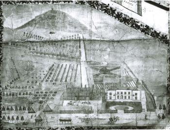
View of The Old House and Red House towards Wednesdon from a map of 1745 [X30/1]
Landscape
Volume III of The Victoria County History for Bedfordshire was published in 1912. At that date the parish of Aspley Guise contained about 2,700 acres of which 382 acres were arable and 758 used for grazing animals; just over 665 acres was woodland. Changes in boundaries have altered the acreage of the parish since that date.
The bulk of the parish's solid geology is a sandstone known, appropriately, as Woburn Sands Formation, formed between 99 and 121 million years ago in the Cretaceous Period in an environment dominated by shallow seas, The scarp slope leading to the lower land north of the church around the railway has a thin band of head - gravel, sand, clay and silt formed up to two million years ago in the Quarternary Period.
Most of the underlying geology of the slope and of the flat land to the north leading towards Salford is Oxford Clay - mudstone formed 154 to 164 million years ago in the Jurassic Period in warm, shallow seas. At one point along Salford Road a sand pit and a clay pit adjoined one another. A thin band of superficial alluvium (clay, silt, sand and gravel formed in the Quarternary Period) follows the stream flowing north from the area near Aspley House known as The Lakes. The crops grown in 1912 were barley, wheat, oats and beans.
Aspley church stands at a height of around 365 feet above sea level. The railway station at 280 feet. The bulk of the village lies between 300 and 450 feet. In the 19th century Aspley Guise was considered the healthiest place in Britain. This was largely on account of it having the smallest difference between summer high and winter low temperatures of anywhere then measured. This, combined with the attractive woodland, in particular the pine woods on the Heath, led to three sanatoria being built for sufferers from tuberculosis
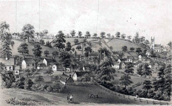
A view of Aspley Guise in the 19th century looking towards the rear of Moore Place with the church in the background [X67/934/14b]
Name
The name Aspley was first recorded in the charter setting out the boundaries in 969 as Aepslea, by which it was known as late as 1229. Other variants of the name include Aspeleia (1086 - the Domesday Book), Aspele or Asplelegh (1202 and later) and Aspeleye Gyse (1363). The word Aspley is Old English for "aspen-tree clearing". The Guise element comes from the French family of Gyse or Guise (from the town and commune of Guise in the northern French département of Aisne) - Anselm de Gyse (or Guise) being granted the Manor of Aspley by King Edward I in 1276.
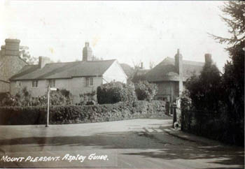
The junction of Mount Pleasant with Bedford Road (then called East Street) about 1920 - the gable on the extreme left is 26 Bedford Road, the other houses were knocked down and now lie under Blackburn House [Z818/32]
Administrative History
Aspley Guise is an ancient parish, indeed, its boundaries were established as early as 969, a charter of the year still surviving (though not held by Bedfordshire & Luton Archives & Records Service). At that date the parish seems to have included the later parish of Hulcote as a hamlet. Aspley Guise formed part of the Manshead Hundred. The parish was relatively large into the 19th century, containing 3,299 acres (1,283 hectares) until 1883 when Aspley Heath, containing 600 acres, was split off from Aspley Guise, becoming its own civil parish.
The boundary line between Hulcote and Salford to the north and Aspley Guise to the south used to follow the line of the stream on which Hulcote Mill stood. In 1984 the boundary was changed to be the middle of the M1 thus giving Hulcote and Salford a good deal of additional land, including the area known as Salford Ford in the vicinity of the Red Lion [CDP82].
Aspley Guise is bounded by the Bedfordshire parishes of Hulcote and Salford to the north, Husborne Crawley east, Woburn south and Aspley Heath south-west; it is also bordered to the west by the Buckinghamshire parishes of Woburn Sands and Wavendon. Modern boundary changes have altered the boundary between Aspley Guise and the Buckinghamshire parish of Woburn Sands especially that of 1965 which saw all the houses on the north side of Aspley Hill from the junction of Downham Road to the junction with the High Street in Woburn Sands transferred out of Aspley Guise and houses at the angle formed by Weathercock Lane and Station Road transferred into Aspley Guise, as well as a large quantity of land east of Station Road and north of Weathercock Lane. By the end of 1979 the area of the parish was just 1,899 acres (739 hectares).
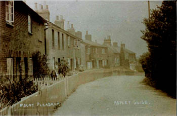
Mount Pleasant about 1920 [Z818/34]
Population
In 1086 the manor of Aspley was noted as containing 16 villagers, 4 smallholders and 5 slaves - 25 people. This figure should be multiplied by a factor of at least four to account for these men's dependents giving a total population of, perhaps, a little over a hundred, about average for a Bedfordshire parish of the time.
The Hearth Tax of 1671 (transcribed in Bedfordshire Historical Records Society Volume 16 in 1934) records 57 dwellings in Aspley Guise for a total of 112 hearths. It has been estimated that this represented a population of about 285. The largest number - nine - was in the house of Widow Cartwright. The house of William Smith included a forge, suggesting that he was the blacksmith. Ten persons in the parish "received constant alms".
Volume 81 published by the Bedfordshire Historical Records Society (2002) is devoted to returns made during episcopal visitations to the county by the Bishop of Lincoln in the early 18th century, edited by former County Archivist Patricia Bell. One of the questions asked was the number of families in the parish; the various responses were as follows:
- 1706: 56 families;
- 1709: 73 families "Souls about 300";
- 1717: four score i.e. 80 families;
- 1720: "Between 50 and 60 familys"
In modern times Aspley Guise has always had a reasonably sized population as the figures below show. The significant drop between 1881 and 1891 is accounted for by the creation of Aspley Heath from part of Aspley Guise. The population rose significantly between 1931 and 1981 as many new houses were built. Latterly the population has fallen and remained steady due to Aspley' being in an area of Green Belt and due to rapidly rising house prices meaning village children often having to move away when they reach adulthood and want a home of their own.
- 1801 - 679
- 1811 - 825
- 1821 - 848
- 1831 - 1,014
- 1841 - 1,139
- 1851 - 1,303
- 1861 - 1,437
- 1871 - 1,519
- 1881 - 1,445
- 1891 - 1,230
- 1901 - 1.261
- 1911 - 1,277
- 1921 - 1,231
- 1931 - 1,105
- 1951 - 1,533
- 1961 - 1,921
- 1971 - 2,046
- 1981 - 2,289
- 1991 - 2,171
- 2001 - 2,183
- 2011 - 2,195