Aspley Guise Maps
The following maps are only a selection of those held at Bedfordshire and Luton Archives and Records Service. To see a larger version of each map, please click on the relevant thumbnail
Pre-Inclosure

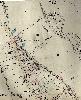
This map was made in 1745 and shows the landholding in the village before inclosure; note that the top of the map west.
Inclosure

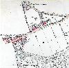
Aspley Guise was inclosed in 1761, the second parish in the county to undergo parliamentary inclosure, and this map was probably created in that year or slightly later. The map is not to scale and is at first difficult to interprete, the easiest way to use it is to find the church and look to the left to find The Square. Note that Spinney Lane does not, at this time, run from Woburn Lane to Mount Pleasant as it stops more or less where the school currently stands [MA94]

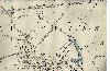
This part of the Inclosure Map showing the Mill and Radwell pit (above).
1st Edition Ordnance Survey 25 Inches to the Mile Maps
The lower part of Weathercock Lane in 1883 showing the county boundary and almost nothing on the Aspley Guise side
The upper part of Weathercock Lane and Aspley Hill in 1882, showing the county boundary (since changed)

West Hill, Woodside and Woburn Lane in 1882

West Hill, The Square, The Avenue, Church Street and the western part of Bedford Road in 1883
The lower part of Church Street, Salford Road and the upper part of Wensdon in 1883

Bedford Road, Wendson and Mount Pleasant in 1883