The Parish of Totternhoe in General
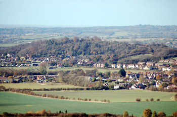
Totternhoe seen from Dunstable Downs November 2009
Landscape
Volume III of The Victoria County History for Bedfordshire was published in 1912. At that date the parish comprised 2,321 acres of which 1,342 acres, 2 roods was arable land producing wheat, barley, beans and turnips, 347 acres, 2 roods was permanent grassland and 16 acres were woods.
The lowest point in the parish is in the north, near the former Stanbridgeford Station which used to be in Totternhoe but early in the 21st century was reallocated to Stanbridge. The ground here is around 300 feet above sea level. The ground rises sharply to around 400 feet in the centre of the village and gets up to around 800 feet in the south-east of the parish on the downs. The castle, which dominates the village, lies around 580 feet above sea-level.
The village is strung out along Well Head Road and then Castle Hill Road and originally comprised three separate ends. Lower End lay in the north-west, around the slope up to Totternhoe Knolls and the castle; Middle End, the main part of the village lay south-east from here and south-east of Middle End lay Church End.
The solid, or underlying geology is, as one would expect, chalk. However, there are three different types, all laid down in the warm, shallow seas of the Cretaceous Period:
- Holywell Nodular Chalk Formation and New Pit Chalk Formation, laid down between 89 and 99 million years ago.This lies in the area of the London Gliding Club at the foot of Dunstable Downs.
- West Melbury Marly Chalk Formation laid down between 94 and 99 million years ago. This rock underlies Church End, Middle End south of the road, the inhabited part of Lower End and the low lying ground south-west of the village.
- Zig Zag Chalk Formation, laid down between 94 and 99 million years ago. This underlies Middle End north of the road, the eastern part of Lower End and the area around Well Head.
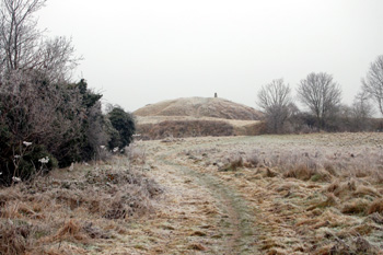
View to the motto of Totternhoe Castle December 2008
Name
The name Totternhoe means "look-out house promontory". This clearly refers to the high ground around Totternhoe Castle and suggests that there was an Anglo-Saxon fortress on or near the same site (the first reference to the Norman castle is in the 1170s), or, perhaps, it refers to prehistoric features such as nearby Bronze Age ring ditches or early fortifications obliterated when the castle was built. The site has such commanding views that it is easy to imagine prehistoric fortifications such as an Iron Age hill fort on the site. The name has undergone a wide variety of forms:
- Totenhou: 1086;
- Toternho: 1160-1350;
- Toternhou: 1160-1350;
- Toterho: 1176-1302;
- Toterhou: 1176-1302;
- Totherno: 14th century;
- Tothirno: 14th century;
- Totenho: 1247-1497;
- Thoturno: 14th century;
- Totorno: 1332-1352;
- Toturnowe: 1338-1347;
- Totourno: 1393;
- Toturnho: 1412-1463;
- Toturhoo: 1428;
- Toternoo: 1503-1526;
- Toternhoo: 1503-1526;
- Tatternall: 1576;
- Totternhoe: 1657 to date;
- Tatternhoe: 1780-1820.

The head of a Parish Council noticeboard February 2010
Administrative History
Totternhoe is an ancient parish in the Manshead Hundred. It is bounded to the north by Stanbridge and Tilsworth, to the north-east by Houghton Regis, to the east by Kensworth, to the south by Whipsnade and to the south-east by Eaton Bray. In 1933 an area either side of the Icknield Way including the locality known as California and the prehistoric monuments of The Five Knolls and the Maiden Bower were transferred from Totternhoe to the Borough of Dunstable. A significant number of boundary changes took place in 1985 in which small parts of Totternhoe were transferred to other parishes. Amomng the most important changes was the transfer of Doolittle Mill to Eaton Bray [MCDP87/5].
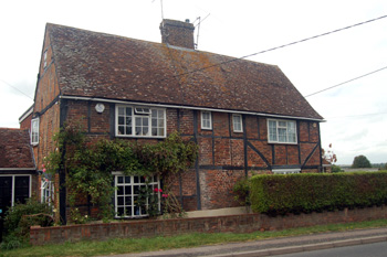
281 and 283 Castle Hill Road August 2009
Population
The population of the two main land holdings in Totternhoe recorded in the Domesday Book is 40: 26 villagers, 6 smallholders and 8 slaves. This number has to be multiplied by a factor of at least four as Domesday Book records only the heads of household. This gives a figure of over 150, meaning that Totternhoe's population was large by the standards of the day.
The population of Totternhoe rose steadily in the early 19th century peaking at 753 in 1851. Increasing agricultural mechanisation then began to decrease jobs in the countryside, leading to the population declining to its lowest point in 1921 as people moved to Dunstable and other towns to find work. The population of Totternhoe grew hugely between 1951 and 1971 (doubling from 884 to 1,778) before falling away again, due to boundary changes as land was transferred from Totternhoe to Dunstable, to 1,181 in 2001.
- 1801: 332;
- 1811: 375;
- 1821: 450;
- 1831: 515;
- 1841: 656;
- 1851: 753;
- 1861: 653;
- 1871: 720;
- 1881: 707;
- 1891: 612;
- 1901: 525;
- 1911: 450;
- 1921: 449;
- 1931: 592;
- 1951: 884;
- 1961: 1,566;
- 1971: 1,778;
- 1981: 1,605;
- 1991: 1,272;
- 2001: 1,181;
- 2011: 1,172.