College Farm Keysoe
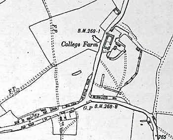
College Farm on a map of 1901
College Farm stands some way out of the centre of the village on a spur off Keysoe Row West. The farmhouse was listed by the former Department of Environment in August 1983 as Grade II, of special interest. It is thought to date from the late 16th or early 17th centuries “with later addtions”. It is timber-framed with some coarse rubble, some brick and some roughcast casing – the whole body of the building being colour-washed. It has a clay tiled roof and is built in an H-shape. The north wing, of two storeys is dated as 16th century and is linked to a 17th century south wing of two storeys with attics. There is also a one storey 20th century infill between the two wings to make the cross bar of the “H” as well as a lean-to addition at the south. The listing notes that the 17th century block has stopped, chamfered beams, a built-in cupboard and panelling with arcading design along the top to the fireplace wall of a first floor room. The farm's name may come from Trinity College, Cambridge, holders of the advowson from the reign of Henry VIII (1509-1547) into the 20th century.
In 1782 particulars of the farm, then in the tenure of Simon Folbigg were drawn up. The value was established as £214/1/28. The individual closes of land were valued as follows [C1687]
- Farmhouse, barns, stables, yard and garden: 1 acre, 3 roods 1 pole;
- Wakelings: 6 acres, 6 poles – meadow, good sward (some patches excepted, subject to burn) – 2/- per acre;
- New Close: 4 acres, 3 roods, 3 poles – pasture or ley, of a middling quality 13/- per acre;
- Lay Close (formerly in two): 16 acres, 2 roods – pasture or ley, the lower side cold, hungry, some part morassy ye upper side better land 10/- per acre;
- Oat Close: 10 acres, 2 roods, 18 poles – arable now ley chief part of a poor, thin chalky soil 6/- per acre;
- Wheat Close (alias Broad Close): 12 acres, 1 rood, 7 poles – arable, now wheat (except a large border of sward ground) - 7/6 per acre;
- Hangmans Close: 4 acres, 1 rood, 27 poles – arable now pease, the land of a cold, livery soil 6/6 per acre;
- Bushy Close: 6 acres, 1 rood, 34 poles – meadow or sward overrun in places with anthills very improvable by good husbandry 12/- per acre;
- Grove Close: 5 acres, 3 roods, 25 poles – part sward other part arable, the land but of a Judist quality 7/6 per acre;
- Smith Croft: 3 acres 2 roods, 14 poles – pasture the upper end middling, bottom poor and flaggy part morassy 7/- per acre;
- Bull’s Pightel: 1 acre, 1 rood, 15 poles – meadow good land, and fine water therein for cattle 20/- per acre;
- Robinson’s Pightel: pasture or sward, good sweet herbage 19/- per acre
The other land was in strips in the common fields.
The Rating and Valuation Act 1925 specified that every building and piece of land in the country was to be assessed to determine its rateable value. The valuer visiting College Farm [DV1/H22/82] found it owned and occupied by J Hartop. In 1891 the rent had been £150 per annum, going up to £180 in 1895. The farm comprised 320 acres, including 33 acres in Thurleigh. A colleague of the valuer commented: “3rd generation. Know it by heart. Very good Farmer. Well balanced, good pasture. Good Farm well farmed. House old, homestead very good”.
The house contained two reception rooms, a kitchen, a dairy, a beer cellar and a pantry with five bedrooms and an attic lumber room. Coal and wood barns stood outside together with a wooden privy. The mostly brick and slate homestead buildings were in a number of groups:
- A cow place for eight; five loose boxes; a mixing place; an open hovel; a stable for eight with a chaff box; a three-bay open hovel; an engine pen; a granary for grinding etc.; a four-bay open hovel; a fenced cow barn; a cow place for five and a loose box;
- Fronting the house were: a loose box; a garage; a nag stable for two and a fowl house;
- Left of the house was a hen house;
- In the field behind the house were: three loose boxes and a two –bay open hovel and yard;
- Right of the main block was: a two-bay implement hovel and a four-bay open hovel;
- In the stackyard were: an eleven-bay lambing shelter with a yard and loose box and a tractor house.
On 16th February 1941 a parachute with the markings "Nicholas L55 Kurt Veterhassel 24.11.38" dropped at the farm, with no one in it on the same night as inscribed piece of metal at Manor Farm, Bolnhurst [WW2/AR/CO/2/3]. One can only presume that a German bomber was desperately trying to lighten its load to stay airborne after receiving damage. No German airrcaft was reported as crashing in the county that night.
Bedfordshire Archive and Record Service has a drainage plan for the farm [RDBP3/1028] for 1948. In 1992 applications were made to convert farm buildings into a restaurant [BorBTP/92/0314] and to create a riding establishment [BorBTP/92/0333].