Top Farm Kempston Rural
Top Farmhouse March 2012
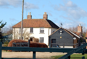
Top Farmhouse was listed by English Heritage in August 1987 as Grade II, of special interest. It dates from the 18th century and the exterior walls are covered in colourwashed roughcast. The property comprises two storeys beneath an old clay tiled roof.
The Rating and Valuation Act 1925 specified that every building and piece of land in the country was to be assessed to determine its rateable value. The valuer visiting Top Farm [DV1/H1/26] found that it was owned and occupied by "Hichen". This may be Edwin Hitchens who, Kelly's Directory for 1928 states, was a farmer at Box End. A later hand has annotated this: "Kightley, now E. Ray". The farm comprised 156 acres and included two tied cottages. The valuer commented: "Quite a useful dairy farm but land inconvenient. Farm lies a long way about".
The farmhouse comprised two reception rooms, a kitchen, scullery and dairy with a cellar beneath and five bedrooms and a bathroom (a later hand has added "W. C.") above. An earth closet stood outside and water came from a pump. Also outside was a brick and slate coal and wood barn.
The homestead comprised: a brick, wood and slate cow shed for twelve beasts; a wood, slate and tiled cooling place; a co shed for fifteen ("not used"); a wood and slate barn; a brick and slate nag stable for two; a coachhouse; four calf pens; a mixing house; a stable for four; two corrugated iron loose boxes and a tie-up for four cows; a brick and corrugated iron bull box; a wood, brick and tiled seven bay cart shed; a wood and corrugated iron store shed; four pigsties and a meal house. This has later been annotated and a granary and twenty one piggeries added. This later hand has commented about the farm buildings: "Poor position".
Alterations to the farmhouse were carried out during World War Two [RDBP3/270]. In 1991 an exterior wall was re-constructed [BorBTP/91/1112/LB]. A map of the extent of the farm in 1918 is held by the University of Reading