Piper's Highway, Carlton
This page has been written by volunteer Pamela Hider
Piper's Highway is an ancient Green Lane running in a north easterly direction from what is today, Eden's Lane, north of the old Fishers farm and towards the main road to Pavenham. Our earliest map showing this lane, thus named, is described as a plan showing Green Lanes etc. in the parishes of NW Bedfordshire - a water colour on tracing linen, which is undated, but thought to be mid- late 19th century (X65/131), thus it is post Enclosure. Before 1806, the main road where the lane would have terminated was the old main road to Stevington, south east of the modern road to Pavenham and no longer extant today.
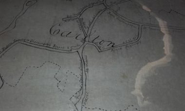
Extract from mid-late 19th century map (X65/131)
An earlier map of one hundred years before, Jefferys map of 1765, also shows this lane, here marked in blue.It will be noted that at this time, the lane extended westwards to meet what is today, School Lane, which was a thoroughfare leading to Turvey and Bedford. Several buildings can be seen on the map along this part of the lane, which came to be known as Church End Road. They were thought to be the 14 small tenements (called Church Houses), mentioned in a glebe terrier of June 1822 (FAC 35/11), the rents of which were paid to nearby St.Mary’s church. That part of the lane and the tenements no longer exist, but a line of earthworks remain along the length of the site.
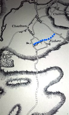
Jefferys map 1765 showing Pipers Highway in blue
Who was Piper? The name first appears in our documents in 1668 (GA1205), where a reference is made to a close called Pipers (in the area of Fishers Farm). 'Pipers Way' is referred to in 1678 (GA359); and also in 1680 (GA339) in connection with Gideon Fisher; 'Piper's Highway' is so called for the first time in 1765 (Z178/7); and 'Great & Little Piper's Closes' are referred to in 1774 (GA598). The origin of the name remains a mystery, but it has continued down the ages, not only attached to a highway, but to a homestead on the Fishers Farm Estate.
Piper's Cottage also known as Piper's Lodge
We know there had been a mansion, a farmhouse and one or two small cottages on the estate (see Fishers Farm). The Land Tax Records of 1825 referred to "a small house" and this could possibly have been the cottage called Pipers in the 1841 census. It was called Pipers Cottage in 1851, 1861 & 1871 and Pipers Lodge in 1881. By 1891, it was again Pipers Cottage and had become divided into 'No.1' and 'No.2', the latter being 'Uninhabited' (Fishers Farm was also described as 'Uninhabited' in 1891). A farmer and his family in occupation at Pipers 'No.1' were to be found living in the High Street in 1901 and in Stevington by 1911, a cottage named Pipers not being mentioned at all in the census for those years. However, the 1910 Ratings (DBV1/25) stated the owner of Piper's Lodge to be J.Skevington and the occupier to be Thomas Eden (father of Harold & Gerald at Fishers). This last may have been a temporary arrangement as Thomas & his family are known to have lived in Grendon, Northants. After 1910, it seems as if the Cottage/Lodge became derelict and was perhaps put to other uses. The 1926 Rating & Evaluation at Fishers described 'Pipers Lodge' as a 'stone and tiled barn (other buildings burnt down)'.
Where was it?
The beginning only and the end only of a former track running from the old Stevington road up to the Fishers site and beyond, can be seen on Jefferys map of 1765 south of and parallel to Piper's Highway. It is possible that this track led to the old Fishers Mansion, which then would have been accessible from both east and west and would have been convenient to walk to and from the village. Along this track to the east, close to the main Fishers site, are earthworks indicating the site of a building which could have been Piper's Lodge (since confirmed, see Wykes Farm). To the west, it would have gone on to join the present day School Lane
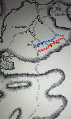
Jefferys map 1765 showing Pipers Highway in blue & track through Fishers in red. Suggested site of Piper's Lodge in yellow.
Today, Fishers Farm and the mansion no longer exist, nor does Piper's Lodge and nor does the track passing close to these places. The old Stevington Road was replaced by the building of Pavenham Road to the north east, in the early 19th century. Piper's Highway, however, still exists and is named as thus on current street maps.
Below is a view of the area made in Google Earth, from the east, with 3D buildings superimposed, based on the 1765 map.
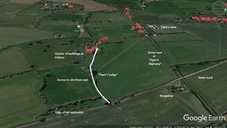
(Courtesy of Matt Tuohy from his thesis on The Hundred of Willey at Leicester University - click to enlarge)
When the old Stevington Road was replaced by the building of Pavenham Road to the north east, in the early 19th century, this led to an extension of Piper's Highway to meet the new Pavenham Road. By the early 20th century, this extension had become known locally as Gypsy Lane as Romany travellers would stay there as they passed through.
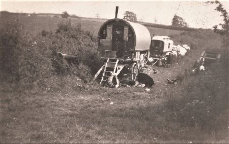
Romany Caravans in Pipers Highway, early 1930s (Courtesy of Carlton & Chellington Historical Society)