The Parish of Swineshead in General
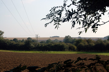
Looking east from Sandye Lane September 2008
Landscape
Volume III of The Victoria County History for Bedfordshire was published in 1912. At that time the parish of Swineshead comprised 1,353 acres, 2 roods. 405 acres, 2 roods were arable farmland, 551 acres were permanent grass and 120 acres, 3 roods were woodland. The main crops were wheat, barley, beans and peas.
The parish is shaped rather like a stone arrow head thrusting north-east. The village lies in the centre of the parish.
The underlying geology is a mudstone called Oxford Clay Formation which was laid down in warm, shallow Jurassic seas between 154 and 164 million years ago. North and west of the village this is overlain by a superficial geology of diamicton called Oadby Member and in the south is a river terrace deposit of sand, gravel, clay and silt. A stream in the south-east part of the parish had limestone and gravel pits nearby.
The parish is relatively flat and low lying. The church is about 170 feet above sea-level, Green End Farmhouse is nearly 190 feet and Swineshead Wood stands at 280 feet above sea-level.
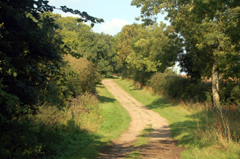
Sandye Lane looking north September 2008
Name
Swineshead is first recorded in the Domesday Book of 1086, when it was written Suineshefet. Over the years the name has gone though many different versions, many of them comparatively recent, as follows: Swyneshaued (1209); Swynesheued or Swinesheued (1209 to 1428); Swyneheued or Swineheued (1247); Swinehefd (1247); Swynyshed (1525); Swaneshed (1526 to 1535); Swanneshed (1542); Swanshed (1549); Stanshed (1575); Swanshedd or Swyneshedd (1585); Swanshead or Swinshead (1595); Swaynshead (1630); Swinhead (1675) and Swinshead (1765).
There is some dispute as to the meaning of the name. One theory, as put forward by A.Mawer and F,M,Stenton in Bedfordshire Place Names is that it means just that, a swine's head. The theory is that posts with animal's heads on them, or representations of them, were set up to mark a place for public meeting. The later changes in name probably owe much to the dislike of the inhabitants to being associated with pigs, preferring the nobler swan. The other theory, as put forth in the Oxford Dictionary of English Place Names is that it means pig's hill, perhaps from the grazing of swine on the slopes.
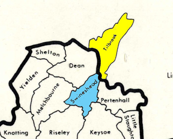
The respective positions of Swineshead and Tilbrook
Administrative History
For most of its existence Swineshead, an ancient parish, lay in Huntingdonshire, in the Hundred of Kimbolton, even though it was entirely surrounded by Bedfordshire parishes (Tilbrook to the north-east, Pertenhall to the east, Keysoe to the south-east, Riseley to the south-west, Melchbourne to the west and Dean to the north-west). On 30th September 1896 the civil parish Swineshead was transferred into Bedfordshire in exchange for Tilbrook, which was transferred into Huntingdonshire, an eminently sensible arrangement as a glance at the map above will show.
Until 1914 the ecclesiastical parish remained in the Rural Deanery of Kimbolton, part of the diocese of Ely. When Bedfordshire was moved into the diocese of St.Albans in 1914 Swineshead was moved into Riseley Rural Deanery, becoming part of Sharnbrook Rural Deanery in 1970.
In 1977 the parish of Pertenhall, which hitherto simply had a parish meeting, rather than a parish council, decided to investigate forming a joint parish counci lwith Swineshead. The Pertenhall Parish Meeting minute book [PCPertenhall1a/1] tells the story:
- 21 March 1974 Annual Parish Meeting-- possibility raised of forming a Parish Council.
- 13 March 1975 Annual Parish Meeting-- discussion of possibilities of a Parish Council at Pertenhall; 'after discussion it was agreed that Swineshead should be approached with a view to forming a joint Parish Council'.
- 25 March 1976 Annual Parish Meeting-- agreed to 'arrange a meeting of representatives of both parishes with Mr. S. Morris the secretary of the Parish Councils Association'.
- 21 July 1976, Special Parish Meeting-- resolution unanimously accepted to establish 'a parish council... in conjunction with Swineshead and to instruct the Chairman to take all necessary action to secure such an establishment'; further proposals and adoptions thereof are noted in minutes.
- 27 January 1977, Special Parish Meeting-- records that the 'notice with the Seal for the new combined Parish Council of Pertenhall and Swineshead' had ben received and now up to Pertenhall and Swineshead to appoint their members for the Council and that if an election was needed it would take place on Thursday, March 17th 1977.
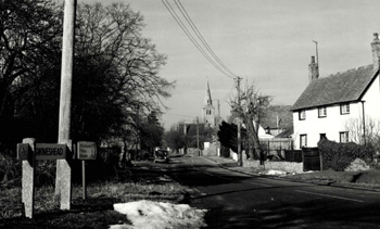
Swineshead High Street looking west in 1979 [Z50/120/10]
Population
At the time of the Domesday Book in 1086 Swineshead was reported as only having one freeman, eight villagers and five smallholders - a total of fourteen. Allowing for an average of three dependents for each of these men, plus representatives of the Lords of the two Manors this would give a total population of around 60, by no means the smallest in the area at the time.
Volume 81 published by Bedfordshire Historical Records Society (2002) is devoted to returns made during the episcopal visitations to the county by the Bishop of Lincoln in the early 18th century, edited by former County Archivist Patricia Bell. She has also included Swineshead, although this was then in Huntingdonshire. One of the questions asked was the number of families in the parish; the various responses were as follows:
- 1706: 40 families;
- 1709: 42 families, "souls 194";
- 1712: 36 families
A very rough calculation would suggest that if the number in a family averaged four the population at this time must have been around 140 to 170.
Census returns for Swineshead show a major fall in population at the end of the 19th century. This was, no doubt, due to jobs on the land growing scarcer forcing families to move away to find work. The lowest level of population came in 1961 since when new housing has prompted a modest growth of population in this attractive village, back to the same levels as the beginning of the 18th century
- 1801: 214;
- 1811: 229;
- 1821: 245;
- 1831: 262
- 1841: 294;
- 1851: 267;
- 1861: 275;
- 1871: 259;
- 1881: 240;
- 1891: 178;
- 1901: 160;
- 1911: 138;
- 1921: 129;
- 1931: 124;
- 1951: 115;
- 1961: 109;
- 1971: 116;
- 1981: 129;
- 1991: 137;
- 2001: 151;
- 2011: 122.