Girtford Maps
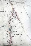
The following maps are only a selection of those held at Bedfordshire and Luton Archives and Records Service. The map below is part of the Sandy inclosure award of 1799 showing Girtford [MA14]. Buildings have been highlighted in red to make them easier to see. To see a larger version, please click on the image
![Girtford in 1799 - buildings highlighted in red [MA14]](/CommunityHistories/Girtford/GirtfordImages/Girtford in 1799 - buildings highlighted in red [M_130x150.jpg)
Girtford in 1799 - buildings highlighted in red [MA14]
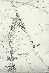
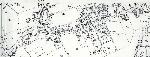
The maps below are from the 25 inches to the mile Ordnance Survey series. Two come from the first edition of 1883 and two from the third edition of 1926. To see a larger version, please click on the image.
The main part of the village in 1883
The main part of the village in 1901
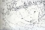
The area of Bedford Road and Girtford Bridge in 1901
The area around Bedford Road and Girtford Bridge in 1926