Clophill Maps
The following maps are only a selection of those held at Bedfordshire and Luton Archives and Records Service. With each of the maps below, please click on the thumbnail to see a larger image.
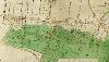
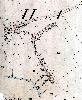
1716 Estate Map
![Clophill and Cainhoe in 1716 [L33-10a]](/CommunityHistories/Clophill/ClophillImages/Clophill and Cainhoe in 1716 [L33-10a]_98x100.jpg)
Clophill and Cainhoe in 1716 [L33/10a]
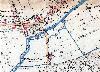
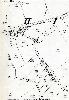
Clophill Inclosure Map of 1826
Clophill Inclosure Map [MA55]
Most Bedfordshire parishes were enclosed in the late 18th or early 19th century. Until then parishes had a few large fields and people owned strips of land in one or more of these fields. Enclosure was a rationalisation of these landholdings. The large fields were subdivided into smaller fields and anyone owning strips became entitled to a proportional allotment of land in the new field layout - usually between one and five of these smaller fields. This, of course, gave us our modern rural landscape of small fields divided by hedges, fences or walls. This map shows Clophill upon its inclosure in 1826. The map is aligned north south, with the modern A6 running down the left hand side and the long road across the sheet about a third of the way down being the road through Beadlow to Chicksands and Shefford. Note the position of the houses marked for comparison with the 1883 Ordnance Survey map.
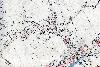
Field names
This Ordnance Survey 6 inches to the mile map was annotated by the first County Archivist, Doctor Fowler, to show the known field names in Clophill
![Field names in Clophill [MC1-3-3-11]](/CommunityHistories/Clophill/ClophillImages/Field names in Clophill [MC1-3-3-11]_98x100.jpg)
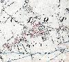
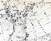
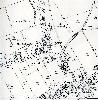
1st Edition Ordnance Survey Maps 25 inches to the Mile Maps
The Green and the area to the south in 1883
The village west of The Causeway in 1883
The village east of The Causeway in 1883
Jaques Lane in 1882
2nd Edition Ordnance Survey 25 Inches to the Mile Maps
The Green and the area to the south in 1901
The village west of The Causeway in 1901

The village east of The Causeway in 1901
 Jaques Lane in 1900